Urban Planning & Design Portfolio
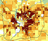
Neighborhood Health Indicators
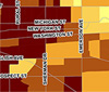
The Neighborhood Health Indicators tool is used to assess current neighborhood conditions and predict future problem areas. The tool provides an information framework for guiding public policy decisions and allocating City resources.
While the tool was created for the City of Indianapolis, it can be adapted for any city, town or municipal entity.
[ Download the Indicators Overview ]
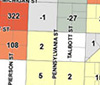
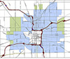
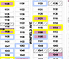
Beech Grove Council Redistricting
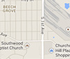
This project created new council districts for Beech Grove, Indiana based on Census 2010 population.
Whether it is for updating voting districts, analyzing school district population or creating and tracking business sales districts, Civicus has the experience for your project.
[ Download the Council District Map ]
Downtown Housing and Population Study
This study analyzed 1990, 2000 and 2010 downtown Indianapolis Regional Center Census block data and tracked population, housing units and residential project trends, while predicting future downtown population.
[ Download the Downtown Study Maps ]
GM Stamping Plant Reuse Study - ULI Briefing Book

This report was created to serve as the briefing book for the Urban Land Institute (ULI) study for the reuse of a former General Motors Stamping Plant in Indianapolis, Indiana. The briefing book contains demographic research, demographic analysis and GIS mapping.
[ Download the ULI Briefing Book ]
Mid North Quality of Life Data Book
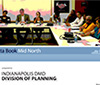
This report was used as a guide book in creating the Mid North Quality of Life Plan in Indianapolis, Indiana. The data book contains demographic research, demographic analysis and GIS mapping.
[ Download the Mid North Data Book ]
EDA Indy FastTrack Project

The Indy FastTrack project provided demographic research and analysis for a grant from the Economic Development Administration of the U.S. Department of Commerce. The funded project will provide an in-depth analysis of four former automotive manufacturing sites.
[ Download the Indy FastTrack Grant Application ]
Indianapolis Urban Enterprise Zone Expansion
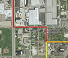
This project created four alternative Urban Enterprise Zone expansion maps based on contiguous land area, population, unemployment and poverty.
Enterprise Zones encourage economic growth and development through tax concession, infrastructure incentives, and reduced regulations to attract investments and private companies.
[ Download the Alternatives Maps ]
Neighborhood Revitalization Strategy Area (NRSA)
The Neighborhood Revitalization Strategy Area (NRSA) project provided GIS spatial analysis to analyze existing boundaries and recommend areas for expansion.
The NRSA Program was established by the Department of Housing and Urban Development (HUD) to encourage local governments to focus some of their Community Development Block Grant (CDBG) funding on highly-distressed neighborhoods.
[ Download the Proposed NRSA Expansion Map ]
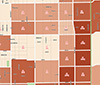
Vacant & Abandoned Housing Strategic Approach
The Indianapolis Vacant & Abandoned Housing Strategic Approach report outlines the development of a "Housing Occupancy Spectrum" to classify the "health" of housing units. "Distressed" housing was further analyzed by Census block groups based on repair orders, vacant/boarding orders, long-term utility disconnections and tax delinquency to predict housing prone to future vacancy. Existing vacant housing policies and programs were reviewed and new policies and programs were proposed.
[ Download the Strategic Approach Summary ]
Technology Park Conceptual Plan
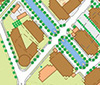
An alternative site plan for a downtown technology research park in Indianapolis, Indiana. The final product was a conceptual design plan for an urban research campus that included pedestrian and auto linkages, water features, higher-density mixed-use development, gateway landmark buildings and preserved open space.
[ Download the Technology Park Conceptual Plan ]
Coke Gas Industrial Plant Reuse Proposal

A proposal for transformative alternative uses for a former coke gas industrial plant in Indianapolis, Indiana. The final proposal included a conceptual urban design plan that included a neighborhood park as the anchor, new residential, mixed-use and transit-oriented development.
[ Download the Industrial Reuse Conceptual Plan ]
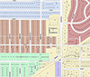
Haughville Neighborhood Study
The Haughville Neighborhood Study catalogued vacant land, tax delinquent properties, foreclosed properties and distressed housing. Four levels of distressed housing were identified and coded based on a combination of housing repair orders, housing boarding orders, tax sale property and long-term utility disconnections.
Contact civicus today about conducting a neighborhood or land use study.
[ Download the Haughville Study Map ]
Midtown Neighborhood Study
The Midtown Neighborhood Study catalogued vacant land, unsold tax sale parcels and distressed housing. Four levels of distressed housing were identified and coded based on a combination of housing repair orders, housing boarding orders, tax sale property and long-term utility disconnections. Additionally, maps were created to highlight Neighborhood Health Indicators and detailed population gain/loss. Proposed TIF district boundaries and eligible Neighborhood Stabilization Program (NSP) Census block groups were displayed for reference.
[ Download the Midtown Neighborhood Maps ]
Lawrence, Indiana Housing Study Map
The Lawrence, Indiana Housing Study Map was created for the Lawrence Community Development Corporation from a digitized, hand-drawn map. The map created five distinct housing study areas based on actual parcels.
[ Download the Housing Study Map ]